Deep Structure
Conceptualising and communicating Perth’s ‘deep structure’ is an essential prelude and catalyst to designing a city that responds to its ecological and hydrological contexts and challenges.
The landscape architect Anne Whiston Spirn (1999) speaks of the importance of the ‘deep structure’ of a place. “This surface structure is thus in flux. Underlying this surface, however, there is a more enduring structure, with distinctive rhythms, to which all organisms within that landscape respond... The significance of the concept of deep structure is to focus attention on the fundamental underlying ecological and geological phenomena that ultimately control the dynamic surface activity.”
Comprehensions of our environment inform how our city is directed and designed. ‘Deep structure’ might frame a view of the city for planners, policymakers and designers of the built environment and become a guide for more responsive design and decision-making across these disciplines.
To think of ‘deep structure’ in Perth is to think physically deep. Extending far beneath the surface of the city are ancient reserves of water. These extensive aquifers are quite particular to the Swan Coastal Plain on which Perth was built. No other Australian city, and few cities globally, share this condition. When they emerge, these deep waters form the tapestry of rivers, creeks and seasonal wetlands that once extended across the entire city.
Old Block AND Young Basin
Perth is a young city on Australia’s ancient edge, a margin between two edges, the Indian Ocean to the west and the Yilgarn Craton to the east. This margin is the Swan Coastal Plain, a relatively young sedimentary basin formed through water. Across its length, the Swan Coastal Plain forms a general environmental condition that varies significantly across the girth from west to east. Limestone and dunal scrubland along the western coast, meet wetland chains or ‘second coasts’, through sedgelands, woodlands and riverine landscapes to the clay plains along the eastern foothills. With “sea to the south and west, desert to the north and east,”¹ George Seddon compared this region to an island.
The Yilgarn is the oldest geological block in the world, igneous and formed by lava. This terrain meets the city of Perth at the Darling Scarp and is a phenomenally ancient landscape. Crystals in the Murchison region have been dated at 4.4 billion years, the oldest terrestrial material ever found.² Over time, this hard granite landscape was weathered down and eroded by water. These flows helped to form the Swan Coastal Plain, a deep layered sedimentary basin. From the east, rich clayey sediments were carried down by Yilgarn rivers and from the west, sands were carried by the tides of the Indian Ocean.
Translated into human timescales, if the Yilgarn Block was an eighty-year-old, the surfaces of the Swan Coastal Plain would have formed in the last three months, and European settlement would have occurred only three minutes ago.³
A phenomenal biological diversity emerged in this landscape. Alternating flows from the Yilgarn and the Indian Ocean formed a layering of clays and sands and a system of rivers, wetlands and aquifers. These conditions, combined with a climate of wet winters and dry summers, supported vast ecological and biological diversity and a high number of endemic species. The southwest of Western Australia is one of 35 recognised international biodiversity hotspots; and in 2013 the World Wide Fund for Nature declared that Perth may be the wildlife capital of the world.⁴
The morphology of Perth as edge and margin, basin and plain explains its linear urban form. Today, the Perth and Peel region is sprawling beyond its poles: Joondalup to the north and Mandurah to the south, an almost continuously inhabited coastline stretching for 150 kilometres. Without any great degree of topographical hindrance, settlement spread on stable sandy grounds and began to fill many of the wetlands with the sands, establishing norms for urban settlement.
Waakal
This wetland landscape is deeply linked to Indigenous culture. The rivers, streams and wetlands are sacred places included in Indigenous stories and culture. The current Perth metropolitan area is the country of the Whadjuk Noongar. The surrounding groups to the south, east and north are, respectively, the Pinjarup, Wiilman, Balardung and Yuat Noongar people. Noongar scholar Len Collard describes the Waakal, or Noongar Rainbow Serpent, as “the Creator, the keeper of fresh water sources”.⁵ Collard explains: “Sometimes it went kardup boodjar (under the earth) and sometimes it went yiraboodjar (over the earth), and it made bilya (river/s), the kaart (hill/s), and ngamar (the waterhole/s)”.⁶ The abundance of resources across this fresh water landscape is tiedto intricate cultural and agricultural practices, ceremony, exchange and trade.⁷ Noongar Elder Noel Nannup describes the importance of water to Indigenous culture: “for us as Aboriginal people, we’re born in a catchment, and where the rain falls and water flows, so does our spirit…that’s our home country, that River knows us.”⁸
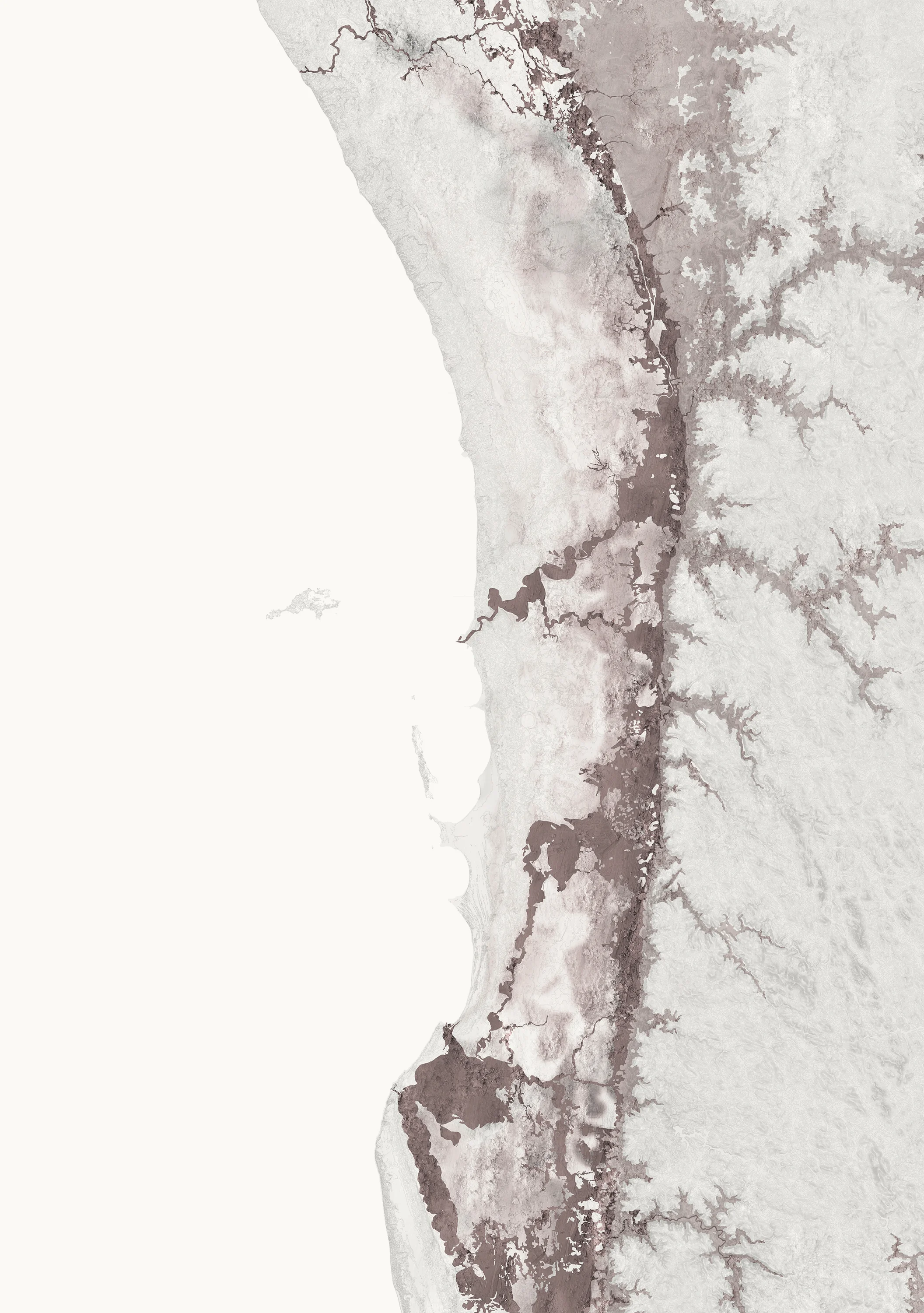
That much of Perth and the Swan Coastal Plain was wetland and swamp is largely unapparent in the contemporary city. Perth shares its swampy past with many other Australian cities, where hydrological grounds were cultivated, converted and filled. Reconstructions of Perth’s historic wetland landscape have been drawn by compiling geological, topographic and hydrographic data. Some of these wetlands are inter-dunal, occurring between sands and limestone, others sit above rich claypans and many were connected to riverine flows.⁹ There has been an enormous reduction in the quantity of wetlands since European settlement nearly 190 years ago. Reconstructions of these wetlands are critical in understanding Perth’s urban ecology today: these maps speak about groundwater systems, drainage paths and the connected lakes and wetlands that remain sensitive ecological sites.
YILGARN Clays
Intermingling sands and clays are fundamental to the deep water story and hydrological conditions of the city. The weathering of the igneous Yilgarn rocks produced the clayey sediments which flowed down onto the plain. The mapping of surface and subsurface clay layers of the plain reveal the widths of the river valleys that once flowed down from the Darling Scarp. The ancient river channels, the paleodrainage channels, carved through the granites of the Darling Scarp and can be read topographically, weathering slowly through ages of rainfall and glacial melting. Another indication of these flows is out to sea at the Perth Canyon, where a large depression carved in the continental shelf aligns with the present-day Swan River.
The historic wetland expanses at the foothills extending to the east of the Swan Coastal Plain are covered in clays. The area to the southeast is known as the palusplain, where sediments from the Yilgarn are most dense, and groundwater is held very close to the surface. Much of this area has been developed for agriculture. These claypans are extraordinarilybiodiverse; around 550 floral species exist at the Brixton Street Wetlands, a tiny wetland near Roe Highway in suburban Kenwick. Much of Perth’s future suburban development is planned to occur in this eastern band of the plain with clayey soils and high groundwater; this is premised on heavy, ‘business-as-usual’ housing development processes: erase, fill, bench and slab.
Indian Ocean SANDS
The ocean was the other agent that formed sedimentary layers on the plain. Sea level fluctuations and winds carried the sands and marine deposits which formed dunes, limestone ridges, and deeper sandstones. In the Eocene epoch (around 50 million years ago), the ocean was at the Darling Scarp, while at the end of the last Ice Age (around 18,000 years ago) the sea level was around fifty kilometres west of its current location. And around 7000 years ago, sand bars bridged Garden and Rottnest Islands with the coast,¹ᴼ (this is well recorded in Indigenous stories).¹¹ The mapping of the sandy geologies reveals the various dunal systems, and the limestone ridges that formed along the coast and the edges of rivers. Many of the inter-dunal wetlands create chains that run parallel to the coast; surface expressions of the groundwater occur between seams and ridges in the sand and limestone.
Aquifer City
Beneath Perth are layers of aquifers; large reserves of underground water held within deep geo-structures. As sediments have been carried down from the Yilgarn, and the ocean has washed over, alternating layers of clay and sand have formed. These clays become the impermeable confining beds for the aquifers, while layers of sand hold the water within them.
The superficial aquifers form mountains of water beneath the surface of the ground. In places, these mounds are expressed as the wetlands on the surface, while in others, groundwater can be thirty metres or more below the surface terrain. To the north of the Swan River, the Gnangara Mound rises to more than seventy metres above sea level, and in the south the Jandakot Mound reaches nearly thirty metres. The interplay between groundwater contour and terrain contour creates areas of high and low groundwater.
Beneath the superficial groundwater are the deeper aquifers, the Leederville Aquifer, and lower still, the Yarragadee Aquifer, storing large quantities of ancient water. The Yarragadee Aquifer underlies the entire Swan Coastal Plain, many kilometres below. The water in the aquifer is thought to be up to 40,000 years old, with temperatures between 39 and 95 degrees celsius, storing 1000 cubic kilometres of water.¹² This capacity is quite extraordinary: the Yarragadee Aquifer could hold almost 2000 Sydharbs (Sydney Harbours).
The connections between water on the surface and groundwater below are well understood by the Whadjuk Nyungar people and are included in their stories, culture and everyday life. Noongar Elder Cedric Jacobs describes this connection with the water in the ground: “The water on the surface is really the marks where the Waakal either wound his way through or came up after making subterranean streams and waterways.”¹³
The aquifer layers of Perth form a hydrological support structure for the city – in places they percolate upwards, in others downwards, and they support the wetlands, rivers, waterways and vegetation. Perth’s ecological and biological qualities are heavily dependent upon groundwater. The aquifers also provide much of Perth’s potable scheme water and irrigation needs through hundreds of thousands of bores. The aquifers are a delicate collective resource which need to be sustained but first understood. The changing climate and diminishing rainfall, along with increased rates of groundwater consumption, have led to significant declines in groundwater reserves. How we engage with the surface through urban design and building design is also implicated in the sustenance and health of our groundwater.
1. G Seddon, Sense of Place: A response to an environment, the Swan Coastal Plain Western Australia, Perth: University of Western Australia Press, 1972, p. xiv.
2. S.A. Wilde, J.W. Valley, W.H. Peck, C.M. Graham, “Evidence from detrital zircons for the existence of continental crust and oceans on the Earth 4.4 Gyr ago”, Nature 409, 2001, pp. 175-178.
3. Based on the following time periods: Darling Scarp geologies 2.5 billion years; superficial formations of the Swan Coastal Plain 1 million years; European settlement 190 years.
4. N Chinna, “Swamp,” Griffith Review 47, 2015, available at: https://griffithreview.com/articles/swamp/#_edn3.
5. L Collard, “The Cosmology: The Creator of the Trilogy Waakal or Nyungar Rainbow Serpent,” in A Gaynor and M Leybourne, eds., Water: Histories, Cultures, Ecologies, Perth: University of Western Australia Press, 2006, p. 129.
6. L Collard, p. 122.
7. M Gibbs, “An Aboriginal fish trap on the Swan Coastal Plain: the Barragup mungah,” Records of the Western Australian Museum 004-015, 2011.
8. N Nannup, “Synergies: Walking Together - Belonging to Country,” video documentary published May 09 2016, available at: https://www.youtube.com/watch?v=aeGqTpLDYjQ.
9. For detailed classifications of Perth’s wetland types see: A.L. Hill, C.A. Semeniuk, V Semeniuk, A Del Marco, Wetlands of the Swan Coastal Plain Volume 2A: Wetland Mapping, Classification and Evaluation, Main Report, Perth: Water and Rivers Commission and Department of Environmental Protection, 1996.
10. I Copp, Geology and Landforms of the South-West, Perth: Department of Environment and Conservation, 2011, p. 5.
11. N Nannup, When the Sea Level Rose, Midland: Swan Catchment Council, 2006.
12. The parameters for Perth’s groundwater system were documented extensively in the early 1990s by W.A. Davidson, Hydrogeology and Groundwater Resources of the Perth Region Western Australia, Perth: Department of Minerals and Energy, 1995.
13. C Jacobs, “General Interview,” interviewed by Maxine Laurie, Town of Vincent Local History Centre, January 8, 2008.